Infomapa Rosario: The City Geographic Information System
Infomapa Rosario: A Geographic Information System for Citizen-Centered Urban Planning
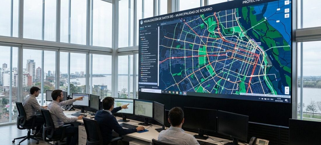
Infomapa Rosario is the public geographic information system (GIS) developed and maintained by the Municipality of Rosario, Argentina’s third-largest city. Launched as one of the earliest open-access urban data platforms in Latin America, Infomapa provides residents, planners, researchers, and businesses with detailed, interactive maps and spatial data covering virtually every aspect of city life — from land use and zoning to transportation routes, public services, environmental conditions, and demographic patterns.
What distinguishes Infomapa from conventional municipal mapping tools is its commitment to open public access. While many cities maintain internal GIS systems for administrative use, Rosario made the deliberate decision to make its geographic data available to all citizens through a web-based platform. This openness reflects Rosario’s broader reputation as a leader in participatory governance and transparent public administration.
What Is Infomapa?
At its core, Infomapa is a web-based GIS platform that allows users to view, query, and analyze geographic data about the city of Rosario. The system integrates data from multiple municipal departments and external sources into a unified spatial framework, enabling users to explore the city’s physical, social, and administrative geography through interactive maps.
The platform is built on a layered architecture where different types of information — called “capas” or layers — can be toggled on and off, combined, and queried. A user might, for example, view the city’s bus routes overlaid on a map of population density, or examine the distribution of health centers in relation to areas of socioeconomic vulnerability.
Data Categories Available
Infomapa organizes its geographic data into several major categories:
- Urban planning and land use: Zoning maps, building regulations, permitted uses by zone, planned developments, and urban expansion areas
- Transportation: Bus routes and stops, bicycle infrastructure, major road networks, traffic flow data, and public parking facilities
- Public services: Locations of schools, hospitals, health centers, police stations, fire stations, libraries, cultural centers, and sports facilities
- Environmental data: Green spaces, urban trees, flood risk zones, air quality monitoring points, and waterway conditions
- Infrastructure: Water supply networks, sewer systems, stormwater drainage, electricity distribution, and public lighting
- Demographics: Population distribution, density maps, and socioeconomic indicators by neighborhood
- Cadastral information: Property boundaries, lot dimensions, and building footprints
- Historical data: Heritage sites, historical districts, and urban development patterns over time
How Infomapa Is Used
By Citizens
For ordinary residents, Infomapa serves as a practical tool for understanding their city. Common citizen uses include:
- Checking zoning regulations before purchasing property or planning renovations
- Finding the nearest public services — health centers, schools, recycling points
- Understanding flood risk for their neighborhood, particularly in areas near the Paraná River
- Exploring transportation options and planning routes using public transit
- Accessing property information for real estate transactions
By Urban Planners and Municipal Staff
For professional planners and municipal employees, Infomapa is an essential working tool. It supports evidence-based decision-making by providing spatial analysis capabilities that help identify patterns, gaps in service coverage, environmental risks, and development opportunities. Planning teams use the system to model scenarios, assess the spatial implications of policy decisions, and communicate plans to the public.
By Researchers and Academics
Rosario’s universities — including the Universidad Nacional de Rosario — make extensive use of Infomapa data for urban research. Studies of transportation equity, environmental justice, public health geography, and urban morphology all draw on the platform’s spatial datasets. The availability of consistent, geocoded data over time enables longitudinal studies that would be difficult or impossible to conduct without a centralized GIS platform.
By Businesses and Developers
Private sector users access Infomapa for market analysis, site selection, regulatory compliance, and logistics planning. Real estate developers use zoning and infrastructure data to assess development potential, while retail businesses analyze demographic and transportation data to inform location decisions.
Technical Architecture
Infomapa is built on a combination of open-source and proprietary GIS technologies. The web interface provides a user-friendly map viewer accessible through standard web browsers, while more advanced users can access underlying datasets through standardized web services (WMS, WFS) that allow integration with professional GIS software like QGIS or ArcGIS.
The system is maintained by the Municipality’s Department of Geomatics, which is responsible for data quality, system updates, and user support. Data is updated on varying schedules depending on the type: some layers (like bus routes) are updated in near-real-time, while others (like census data) are updated periodically as new information becomes available.
Infomapa and Participatory Governance
Infomapa is closely linked to Rosario’s internationally recognized participatory budgeting program, one of the largest and most established in Latin America. Through participatory budgeting, residents directly decide how a portion of the municipal budget is spent, typically proposing and voting on neighborhood-level infrastructure and service improvements.
Infomapa supports this process by providing the spatial data needed to identify needs, evaluate proposals, and track implementation. Residents can use the platform to see where previous investments have been made, identify gaps in service coverage, and make evidence-based arguments for their proposals. This integration of GIS data with democratic participation represents a model of data-informed citizen governance.
Rosario’s Broader Smart City Strategy
Infomapa functions as a cornerstone of Rosario’s broader strategy for data-driven urban management. The city has been recognized as one of the most innovative in Argentina for its use of technology in public administration, and Infomapa exemplifies the approach: making data not just available to government officials but accessible and useful to the public.
Related initiatives include:
- Open data portal: Complementing Infomapa’s geographic data, Rosario’s open data portal provides non-spatial datasets on budgets, public contracts, service delivery statistics, and more
- Citizen reporting systems: Digital platforms that allow residents to report infrastructure problems, which are then geocoded and integrated into the GIS system for tracking and resolution
- Environmental monitoring: Real-time data collection on air quality, water levels, and other environmental parameters, visualized through Infomapa’s mapping interface
Challenges and Limitations
Despite its achievements, Infomapa faces several ongoing challenges:
- Data currency: Keeping all layers up to date requires sustained investment in data collection and processing. Some datasets may lag behind actual conditions, particularly in rapidly changing areas
- Digital divide: While the platform is publicly accessible, its effective use requires internet access, digital literacy, and familiarity with map-based interfaces — capabilities that are not evenly distributed across the population
- Interoperability: Integration with provincial and national datasets remains a work in progress, limiting the ability to analyze cross-jurisdictional issues
- Resource constraints: Municipal budget pressures can affect the staff and technology resources available to maintain and develop the platform
A Model for Latin American Cities
Infomapa Rosario has served as a reference model for other Argentine and Latin American cities developing their own public GIS platforms. Its success demonstrates several key principles:
- Open data creates value: Making geographic data publicly available generates benefits that extend far beyond the original administrative purposes of data collection
- GIS supports democratic participation: When citizens have access to the same spatial information as government officials, public debate becomes more informed and productive
- Incremental development works: Infomapa was not built all at once but has grown over years, adding new data layers and capabilities as resources and needs have evolved
- Institutional commitment is essential: Sustained political support and dedicated technical staff are necessary to maintain a public GIS platform over the long term
For cities across Latin America seeking to improve urban planning, increase government transparency, and empower citizen participation, Rosario’s Infomapa offers a proven, practical approach. It demonstrates that even in contexts of limited resources, a commitment to open geographic data can transform both the practice of urban management and the relationship between government and citizens.